Home / Blog / Getting around
How to plan a bus and rail trip in Malaysia with PantauSivik
PantauSivik 1.68 added a trip planner for Malaysia. You pick a start and a destination, and the app plans a trip by bus and rail with an arrival time, a step by step timeline and a map. This post walks through it in the order you would use it: set up, search, read the plan, follow it, and find it again later.
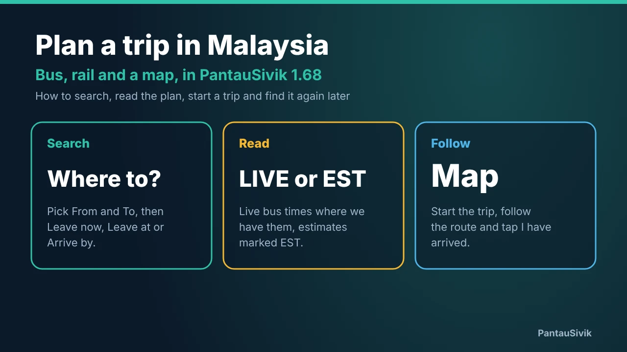
In short: switch the country to Malaysia, open Trip Planner, set From and To, and choose Leave now, Leave at or Arrive by. A LIVE badge means the next bus has a live time. An EST badge means the time is an estimate. Tap Open in map, then Start trip, and tap I have arrived when you get there.
Before you start
- Update to 1.68. The update went live on Google Play on 6 November. Our 1.68 post lists everything else that changed.
- Switch the country to Malaysia. Tap the country pill and choose Malaysia. If Malaysia is where you live, set Home country in Settings, or pick it the first time you open the app.
- Find the planner. It has its own entry in the sidebar and on the More page, and only appears for Malaysia. The Malaysia dashboard also has a Trip Planner card with a Where to? field and up to four of your saved places as chips.
The app and the planner text are available in English, Malay, Chinese, Tamil, Hindi, Japanese and Korean.
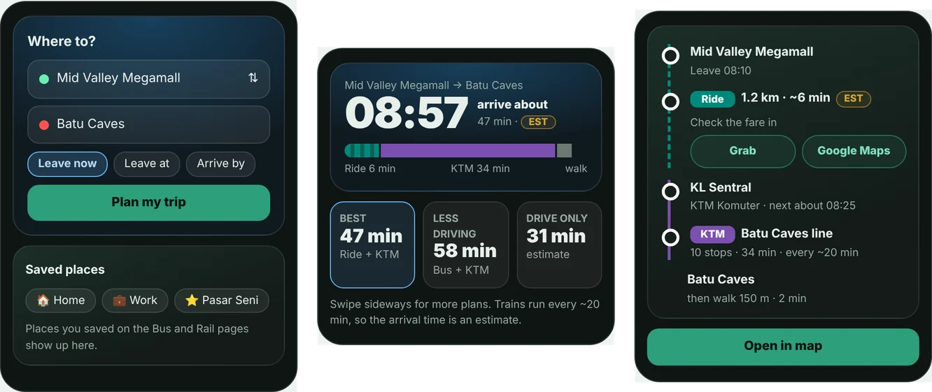
Plan a trip
- Set From and To. Start typing in either field. Suggestions appear right under it: your saved places first, then our own stops and stations sorted nearest first with the distance from you, then addresses. Tap one to select it. For From you can also use your location, and the swap button flips the two.
- Choose the time. Leave now plans from this moment. Leave at lets you set a departure. Arrive by works backwards from the time you must be there.
- Read the result. The plan appears below the form. If you tap Open in map and come back, the plan is still there.
Address suggestions come from Geoapify, and the app shows a credit line when they appear. You can star a place to save it, up to 20 places, and press and hold a saved place to remove it.
Read the plan
The top card shows the arrival time, a coloured bar for the time split between walking, bus, rail and rides, and a badge. Swipe the card sideways to see other plans.
- LIVE appears when the first bus of the plan has a live arrival time. The plan then says Next bus in N minutes and refreshes about every 30 seconds while the screen is open. Live bus times come from our Rapid KL and Penang feeds.
- EST appears when there is no live time. The plan then uses an estimated wait and an estimated ride. Treat it as a guide, not a promise.
- Trains use the KTMB timetable where we have it. Rapid Rail trips are worked out from how often trains normally run, so they are estimates too.
- Walk and ride legs are dashed lines in the timeline. A walk of more than 400 metres is shown as a ride estimate instead. The timeline also has Grab and Google Maps buttons.
Below the top card, a vertical timeline lists each step in order: walk to the stop, which bus or train to take, where to get off, and what comes after. A plan can have one direct trip or one change. A drive only plan is always included, so you can compare.
Follow it on the map
Tap Open in map. The map shows each leg in the colour of its route, with white dots where you change. Walks are dashed purple, and ride legs follow the road when we can get a road line and fall back to a dashed straight line when we cannot. A banner appears if one of your places has no data nearby.
- Tap Start trip. The app shows the same Turn on Live Tracking question as Singapore, then zooms to you and the start point.
- If you are more than 1.5 km from the start, the strip at the top says how far you are until you get closer.
- The strip shows Next: the first bus or train still ahead today, with a live time when there is one. Otherwise it shows the distance to go.
- Use Fit route to see the whole trip, Live tracking to turn tracking on or off, and Center on me to jump back to your position. The camera does not follow you after the first zoom.
- When you arrive, tap I have arrived.
Leave the map and come back
An active trip is saved on your phone. You can leave the map, close the app and come back, and the trip is still there. The Trip Planner card on the dashboard shows the route, the Next line, and the buttons Open map, I have arrived and End trip. If the arrival time passed more than 30 minutes before the next time you open the app, the trip is dropped.
Trip history and recent trips
I have arrived saves the trip with its route, date, start and end time and how long it took. History groups trips by route, newest first, with the latest six per route and up to 20 routes. The page is read only, and you can delete single trips from it.
The Recent trips card on the planner is the quick way back. Tap a route and the app fills From and To, sets the time to now and plans it straight away, without a new address search.
What to keep in mind
- Plans come from the transit data we have. If a place has no stop data nearby, the planner shows a NO DATA card with the nearest stop and a drive note instead of a bus or rail plan.
- Estimates are estimates. Buses may not run to the schedule the app assumes. Check the operator for anything that matters, such as the last train of the night.
- Stops within walking distance. The planner looks for stops up to 1.5 km from each end.
- Singapore has its own planner. This one is for Malaysia. See the Singapore Trip Planner guide for that side.
For the rest of the Malaysia side, such as weather, fuel prices and alerts, see the Malaysia guide.
Common questions
Which version of PantauSivik has the Malaysia trip planner?
Version 1.68, which went live on Google Play on Friday 6 November 2026. Open Google Play and tap Update if you are still on an older version. You can check your version under Settings and About.
How do I open the Malaysia trip planner?
Tap the country pill and choose Malaysia, or set Home country to Malaysia in Settings. Then open Trip Planner from the sidebar or the More page, or tap the Where to? field on the Malaysia dashboard.
Does it show live bus times in Malaysia?
Sometimes. When the first bus of a plan has a live arrival time from our Rapid KL or Penang feed, the plan shows a LIVE badge and Next bus in N minutes. When there is no live time, the plan uses an estimate and shows an EST badge.
Does the planner only cover buses and trains?
It plans bus and rail trips, with walking and short ride legs between them. A drive only plan is always included, so you can compare, and the timeline has Grab and Google Maps buttons.
Where does my trip history go?
When you tap I have arrived, the trip is saved on your phone, grouped by route with the newest first. You can plan the same route again from the Recent trips card on the planner. History stays on your phone.
Information in PantauSivik comes from public sources and is there to help you plan. PantauSivik is independent and not affiliated with the Land Transport Authority or any bus or train operator.
See also: What is new in 1.68, Malaysia guide, Trip Planner guide, Johor to Singapore crossings.